National High School Exit Exam Results Mapped
A new GIS dashboard presents the performance of graduating students by municipality and subject over the last seven academic years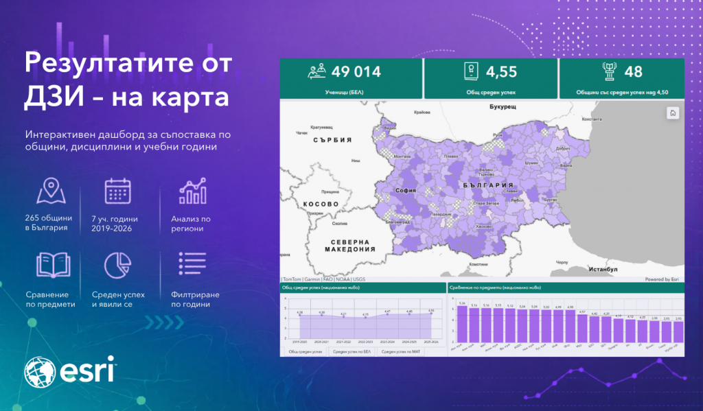 | |
Esri Bulgaria launches Summer GIS Academy for Young Scientists.
Sorry, this entry is only available in Български. | |
„GIS and Climate: Solutions for the Future“ 2026 Hackathon Launches
Sorry, this entry is only available in Български. | |
The Esri Nonprofit Program provides access to GIS software, data, and training
Sorry, this entry is only available in Български. | |
Esri Bulgaria Establishes the “Jeni Karadjova” GIS Scholarship
Applications for the first edition are open until June 25, 2026. | |
EDIH in the Construction Sector Launches Its Second Phase
Esri Bulgaria is also participating in the new phase of the project as part of the hub’s partner network
| |
Interactive WMO StoryMap Presents the State of the Climatе
From record glacier melting to new health risks: how climate change is already transforming our lives | |
The Aqueduct 4.0 data are now freely available in Living Atlas
Aqueduct 4.0 в Living Atlas provides one of the most comprehensive datasets on water risk in the world through the ArcGIS Online platform | |
GIS Transforms Italy’s Railway Stations
How geospatial technologies ensure safety and sustainable modernization | |
The awards in the “Exploring the World with GIS” competition were presented
Deputy Minister Emilia Lazarova awarded the winners in the “Teachers” category | |
Deputy Prime Minister Grozdan Karadzhov opened the World GIS Day
The conference brought together over 900 experts | |
Security, Sustainability, and Digital Twins — on World GIS Day
Leading Experts from the European Commission and Esri to Arrive in Sofia
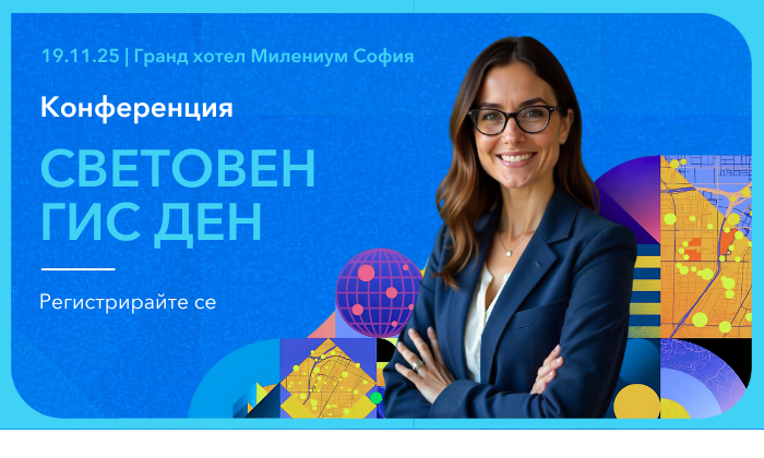
On November 19, Bulgaria will mark the 26th World Geographic Information Systems (GIS) Day with a large-scale conference themed “GIS connects everything, everywhere – for a more sustainable world”. The event will be held at the Grand Hotel Millennium Sofia and is organized by Esri Bulgaria in partnership with 70 leading business, academic, NGO, and media organizations.
This flagship GIS event in Bulgaria is expected to bring together more than 800 participants from government institutions, local authorities, businesses, academia, and the non-profit sector. International and Bulgarian experts will present the latest trends, solutions, and best practices in geospatial technologies. The conference will highlight innovative GIS applications and real-world projects across a wide range of fields, including environment, security, transport, infrastructure, education, healthcare, and resource management.
A special guest speaker at the prestigious forum will be Dr. Bruno Combal, Policy Officer at the Directorate-General for Environment of the European Commission (EC). He will present the EU Biodiversity Strategy for 2030, along with the Habitats Directive and the Natura 2000 network. In his presentation, Dr. Combal will emphasize how GIS technologies and open geodata support the formulation and implementation of the EC’s environmental policies. The session will also highlight the Commission’s environmental information systems powered by advanced GIS technologies, such as the Biodiversity Information System for Europe (BISE) – the EU’s central platform for accessing data and knowledge on biodiversity status and progress toward the Union’s environmental goals.
Also arriving in Bulgaria for GIS Day is Arkadiusz Sadkowski, Global Manager for Reality Mapping Solutions at Esri. He will present the latest technological trends in leveraging GIS to create realistic and dynamic digital twins. Attendees will discover global best practices in both large-scale and detailed reality mapping, applied to urban planning, infrastructure engineering, public safety, and natural resource management.
During the technology session, participants will explore the latest capabilities of the ArcGIS platform – from AI-powered assistants and generative agents to new cartographic techniques, ready-to-use spatial analyses, and advanced 3D and field operations.
The afternoon session will highlight some of the most significant GIS projects implemented in Bulgaria over the past year – from new GIS registries and applications integrated into the Single Information Point of the Ministry of Transport and Communications, in line with EU digital connectivity regulations, to the GIS-based crime prevention system of the Ministry of the Interior, and smart GIS solutions for municipalities, including the new Green System GIS of Sofia Municipality.
Assoc. Prof. Dr. Leonid Todorov from Sofia University will present a geospatial analysis of transport accessibility to emergency medical services in Bulgaria. Additional demonstrations will showcase how GIS technologies are being applied in other key areas such as flood management, healthcare, and education.
Running parallel to the conference will be a virtual exhibition showcasing projects from the National Educational Competition “Exploring the World with GIS,” held under the patronage of the Ministry of Education and Science. The best interactive lessons and story maps created by teachers, students, and doctoral candidates will be recognized at an official award ceremony that same evening.
The event will also feature the first National Student Hackathon “GIS & Climate: Solutions for the Future,” where the winning teams will receive their prizes during the ceremony.
The culmination of the event will be the Annual GIS Awards for Outstanding Achievements, honoring organizations, teams, and experts who have contributed to the advancement of geospatial technologies in Bulgaria.
“World GIS Day is where visionaries, professionals, and enthusiasts come together to inspire and build a more sustainable future through geospatial technologies,” said Miglena Kuzmanova, Managing Director of Esri Bulgaria.
Participation in the World GIS Day Conference is free of charge, but advance registration is required.
The event is organized by Esri Bulgaria.
With the support of:
Schneider Electric; Geographica; EnduroSat; HERE Technologies; Telelink Business Services; Ciela Norma; and Agora 66.
In partnership with:
Bulgarian Academy of Sciences; Faculty of Geology and Geography, Sofia University “St. Kliment Ohridski”; Faculty of Economics and Business Administration, Sofia University “St. Kliment Ohridski”; Faculty of Mathematics and Informatics, Sofia University “St. Kliment Ohridski”; University of Architecture, Civil Engineering and Geodesy; University of Mining and Geology “St. Ivan Rilski”; University of Forestry; Bulgarian Geographical Society; Bulgarian Cartographic Association; American Chamber of Commerce in Bulgaria; National Association of Municipalities in the Republic of Bulgaria; Foundation for Local Government Reform; Bulgarian Association of Information Technology (BAIT); Bulgarian Association of Software Companies (BASSCOM); AFCEA Sofia Chapter; The Atlantic Club of Bulgaria; Union of Surveyors and Land Managers in Bulgaria; Chamber of Builders in Bulgaria;
Union of Architects in Bulgaria; Chamber of Architects in Bulgaria; Union of Urban Planners in Bulgaria; Bulgarian Water Association; Institute for Transport Infrastructure; Road Safety Institute; Bulgarian Red Cross; Green Balkans; Bulgarian Chamber of Mining and Geology; Bulgarian Natural Gas Association; Association of Police Chiefs; MOVE.BG; Digital National Coalition; Bulgarian Industrial Association; Bulgarian Chamber of Commerce and Industry; CMDR CEO; Alliance of the Technology Industry; Association of Electronic Communications; BAGIS;
SCGIS Chapter Bulgaria (Society for Conservation GIS – Bulgaria Chapter); Technical University of Sofia; New Bulgarian University; University of National and World Economy; National University Center for Geospatial Research and Technologies at Sofia University “St. Kliment Ohridski”; University of Library Studies and Information Technologies (ULSIT); Higher School of Telecommunications and Posts; Ruse University “Angel Kanchev”; Georgi Stoykov Rakovski Military Academy; Academy of the Ministry of Interior; Institute of Defense “Prof. Tsvetan Lazarov”; Varna Free University “Chernorizets Hrabar”; University “Prof. Dr. Assen Zlatarov” – Burgas;
Vasil Levski National Military University; South-West University “Neofit Rilski”; Shumen University “Episkop Konstantin Preslavski”; Nikola Vaptsarov Naval Academy; Veliko Tarnovo University “Sts. Cyril and Methodius”; D. A. Tsenov Academy of Economics; Space School; National High School of Mathematics and Science “Acad. Lyubomir Chakalov” (NHMS).
In media partnership with:
bTV Media Group; Dir.bg; Bulgarian National Radio; The City Media Group and National Geographic Bulgaria
### | |
GIS in Action: Analysis and Solutions for Climate Change
A Global Challenge with Local Dimensions
| |
By Europe, for Europe
How Esri’s Local Approach Powers Digital Sovereignty | |
“Exploring the World with GIS” – Expanded Edition with Exciting New Prizes
Teachers, pupils, and students from across the country can easily transform their knowledge and ideas into interactive GIS projects | |
From Maps to Insights: How GeoAI in ArcGIS Transforms Analysis
Sorry, this entry is only available in Български. | |
“The Best Thing About GIS Is That It Connects Knowledge with the World”
Interview with Lalo Lalov, GIS and Databases Intern | |
ArcGIS Urban: The Future of Urban Planning
What will our city look like tomorrow or in 10 years? | |
“This internship gave me invaluable knowledge and confidence”
Interview with Dimitar Belchev, Software Development Intern | |
“GIS is a way to organize the world and find meaning in chaos.”
Interview with Alek Bachvarov, GIS and Databases Intern | |
Selected Teams Announced in the “GIS and Climate” Hackathon
Sorry, this entry is only available in Български. | |
sri Bulgaria participated in “BAIT in Support of Education”
Sorry, this entry is only available in Български. | |
Hackathon ‘GIS and Climate: Solutions for the Future’ has Launched
Bulgarian students from across the country and abroad are invited to take part in a unique research competition focused on climate change | |
ArcGIS and Sentinel-2: Analysis Without Borders with Sentinel-2 Explorer
Sorry, this entry is only available in Български. | |
“Pleven in the 21st Century” – builds a bridge between the city’s past and future
Sorry, this entry is only available in Български. | |
Bulgaria develops a national GIS portal for transport and connectivity
The Ministry of Transport and Communications is expanding its “Single Information Point” (SIP) system by adding new capabilities for multimodal travel, serving citizens, businesses, and the public sector | |
Sofia Municipality presents “Sofia in Maps”
Sorry, this entry is only available in Български. | |
WMO report: 2024 marks new records in global climate
Interactive maps and charts reveal growing risks to the planet
| |
ArcGIS for AutoCAD – More Powerful and Intuitive Than Ever
Sorry, this entry is only available in Български. | |
Unleash the potential of drone data with Drone2Map
Sorry, this entry is only available in Български. | |
Unleash the power of spatial statistics in ArcGIS Pro
Sorry, this entry is only available in Български. | |
The internship was my gateway to the world of GIS
Sorry, this entry is only available in Български. | |
The World GIS Day conference gathered more than 800 participants
Sorry, this entry is only available in Български. | |
NATO and leading international experts arrive for the 25th World GIS Day
Security, sustainable development and smart infrastructure are among the highlights of the GIS conference | |
The biggest educational GIS competition in our country has started
All teachers, pupils, and students can join the national competition and win great prizes | |
Esri App Guides Visitors to “48 Hours of Warusha South”
108 events in 47 locations delight the residents and guests of Veliko Tarnovo from August 16 to 18 | |
GIS improve the quality of life
Blitz interview with Neda Maneva, Marketing intern at Esri Bulgaria | |
“GIS is a vast and constantly evolving field”
Blitz interview with Neda Grigorova, QA intern at Esri Bulgaria | |
“I feel part of a professional and innovative team”
Blitz interview with Nadia Petkova, GIS and database intern at Esri Bulgaria | |
An Esri GIS Map Presents the State of Bathing Waters in the EU
According to this year's report of the European Commission - 96% of the waters for bathing in the territory of the Union are safe for human health | |
“The work we do is really useful for society”
Blitz interview with Konstantin Marinov, GIS and database intern at Esri Bulgaria | |
“GIS is a wide-ranging and dynamic field”
Blitz interview with Kamelia Spahiyska, GIS and database intern at Esri Bulgaria | |
Through GIS, we see the world from a new perspective
Blitz interview with Vesela Fileva, GIS and database intern at Esri Bulgaria | |
The 20th National Olympiad in Geography and Economics was held
The participants sealed their message in a capsule for the contestants in the XXX Olympiad in Geography and Economics in our country | |
Esri launches Maps.com
Maps.com brings together remarkable maps to help people explore and better understand the world through the power of cartography. | |
News Minister Tsokov Presented Awards in the GIS Competition
Sorry, this entry is only available in Български. | |
A record 700+ people participated in World GIS Day 2023
Sorry, this entry is only available in Български. | |
The Biggest GIS Event in Bulgaria Returns in Person on November 15th
Sorry, this entry is only available in Български. | |
National Educational Competition “Exploring the World with GIS” Launched
Teachers, students and students from all over the country can enter and win many prizes | |
The 11th campaign “Let’s Clean Bulgaria Together” was launched
Esri Bulgaria received a special plaque as a technology partner of the largest volunteer initiative in Bulgaria
| |
GIS opens the doors to many new fields for me beyond surveying
Interview with Nicole Nikolova, GIS and Database Intern at Esri Bulgaria
| |
It’s useful for people from all sorts of backgrounds to get involved with GIS
Interview with Venko Venkov, GIS and Database Intern at Esri Bulgaria.
| |
There is something for everyone in GIS technology
Interview with Kubrat Novkov, "GIS and Databases" intern at Esri Bulgaria. | |
In 30 years, access to education has increased worldwide
UN data is presented on an interactive Esri GIS map. | |
GIS is a tool that can contribute to a brighter future
Interview with Viktor Bozev, "GIS and Database" intern at Esri Bulgaria.
| |
We are recording the lowest pH of the oceans in at least 26,000 years
The World Meteorological Organization has presented its 2022 annual climate report in visual form with an interactive GIS StoryMap.
| |
GIS combines everything I expect from a career
Interview with Denis Ivanov, software development intern at Esri Bulgaria.
| |
Esri – with a thank you award for supporting child cartographers
On March 27, the winners of the 13th National Children's World Map Competition "Map of my Future World" were awarded.
| |
They officially presented the medals to our Olympic geography champions
With a total of 7 medals from the last two International Geography Olympiads, the Bulgarian students won for Bulgaria one of the leading places in the world
| |
University Students in Bulgaria Adopt GIS Skills for Careers in Sustainable Mining
Esri prepared a case study for the teaching with GIS process at the University of Mining and Geology. | |
NASA brings new up-to-date Earth data and services to Esri’s GIS platform
A new agreement between the world leader in Geographic Information Systems Esri and NASA will provide the global scientific community with access to more up-to-date and high-quality resources. | |
Esri – 2022 Climate Change Technology Leader
The Esri GIS platform received an extremely high rating in Forrester's Climate Risk Analysis report.
| |
ESRI Bulgaria is waiting for interns!
The Spring Internship Program 2023 is now open for applications. | |
Esri’s Este Geraghty – first among women leaders in medicine for 2022
The ranking features 50 doctors, clinicians and educators who are changing the face of modern medicine
| |
Who’s who at the FIFA World Cup in Qatar
Esri's dashboard integrates in one place maps, statistics and information for all participants in the championship
| |
The conference for the World GIS Day brought together more than 800 participants
Esri Bulgaria together with leading organizations presented the best GIS projects and nationally significant systems in many spheres.
| |
Sustainable development and disaster management – focus of GIS Day 2022
An online conference will showcase the significant GIS systems and innovations in various industries. | |
StoryMaps for Personal Use – a new tool for stories based on the most powerful GIS
Furthering Esri's Mission to Bring the Geographic Approach to All, the new StoryMaps for Personal Use app lets anyone tell and share their stories in the form of engaging, interactive web content
| |
Apply for an Esri NGO grant
Grant application form. | |
Upcoming Webinar – Special Esri Program for NGOs and Conservation
Learn more about new Esri GIS solutions to help NGOs protect biodiversity and natural resources!
| |
The basemaps in Living Atlas of the World – in even higher resolution!
A new agreement between Esri Inc. and Maxar Technologies will provide ArcGIS users with imagery of nearly half the Earth's surface, with resolution enhanced from 1.2 m to 60 cm.
| |
The White House relies on Esri GIS to prevent heat deaths
A GIS portal will help prevent victims of the heat in the USA. | |
Overgas has won the most prestigious international GIS award for 2022
The award is for the innovative GIS platform implemented by Esri Bulgaria for all work processes related to gasification in our country.
| |
Esri Bulgaria with an honorary plaque for partner of “Let’s clean up Bulgaria together”
Since the beginning of the largest volunteer initiative in our country, nearly 2,500,000 volunteers have collected garbage with a volume equal to more than 200 fully loaded Boeing 747 airplanes
| |
3 medals for Bulgaria from the International Geography Olympiad
The team is financially supported by Esri Bulgaria.
| |
“The variety in GIS programming is interesting and develops many skills!”
Interview with Miroslav Mitkov, a participant in the "Spring Intern Program" of Esri Bulgaria.
| |
Registration for the first Summer Online Esri Academy is open
Master ArcGIS Pro, ArcGIS Online and practical applications in just 2 weeks!
| |
“Both in GIS and in music – I have a lot to give to the society!”
Interview with Hristo Kostov, a participant in the "Spring Internship Program" 2022 of Esri Bulgaria.
| |
“I like the scale of GIS projects and their public value”
Interview with Toni Blagoev, a participant in the "Spring Internship Program" 2022 of Esri Bulgaria. | |
“I want to close the perfect circle of GIS skills”
Interview with Denis Antiev, a participant in the "Spring Internship Program" 2022 of Esri Bulgaria. | |
“GIS has the potential to make the world a better place to live”
Interview with Vikitsa Kazasova, a participant in "Spring Internship Program 2022" of Esri Bulgaria.
| |
“With GIS I can focus on what is close to my heart”
Interview with Anzhela Petrova, a participant in the “Spring Internship Program” 2022 of Esri Bulgaria.
| |
The UN FAO has created a dashboard for the war in Ukraine with the ArcGIS Dashboard
Data on people in need, starving and displaced people are updated, systematized and presented using Esri's ArcGIS Dashboard.
| |
Sofiyska voda, Part of Veolia, Modernizes Workflows with ArcGIS Utility Network
The implemented solution helps Sofiyska voda work faster and smarter and provides services of higher quality to residents. | |
ArcGIS Online is now in Bulgarian and with a free version
Sign up for the new upcoming courses and learn how to apply the leading web GIS software to your work.
| |
The application for the Internship Program Spring 2022 has started
ESRI Bulgaria accepts applications until December 10, 2021 in several key areas.
| |
Good GIS practices for sustainable development and access to data main topics of the World GIS Day
The largest GIS event in Bulgaria gathered online more than 800 participants from various fields.
| |
Bulgaria celebrates GIS Day 2021 with online conference on 17 November
How GIS can help achieve the Green Deal and the UN Sustainable Development Goals - find the answer during the largest GIS event in the country.
| |
The First National Educational Competition “Digital Stories from School and University” is open
All teachers, high school students, and Ph.D. candidates can participate in the competition.
| |
(Български) Предстои надграждащ обучителен уебинар по програма “ГИС в училище”
Sorry, this entry is only available in Български. | |
The International Hackathon “Hack for a Sustainable Future” is open
Teams can submit their projects until September 13 on topics related to environmental and socially significant topics.
| |
GIS applications help monitor and report wild fires online
They are created in order to support communication in emergency situations in Bulgaria. | |
Upcoming training related to “GIS at School” program
Esri Bulgaria organizes free training: Work with the provided GIS software and training resources according to the program "GIS at School". | |
Join Esri User Conference
Esri User Conference 2021 will be a virtual event starting from the 12th until 15th of July. Join tens of thousands of GIS users | |
Jack Dangermond honored by IGU with Planet and Humanity Аward
The award is given once in every four years | |
The cleaning actions of “Let’s clean Bulgaria together” are starting and they will be marked on Esri map
Esri Bulgaria was chosen again for | |
Digital map by Esri helps people around the world to participate in Earth Day
Using the global map developed by Esri | |
A introductory training program “GIS in Schools”
Upcoming introductory training under the "GIS in school" program.
| |
Winners of the “Favourite places on the map of Bulgaria” contest
 The first of its kind contest gathered in one interactive map more than 1,600 photos from participants from all over the country. The first of its kind contest gathered in one interactive map more than 1,600 photos from participants from all over the country.
| |
GIS map tracks the progress in the development of vaccines against COVID-19
The world's first coronavirus vaccine tracker is now just a click away. | |