Deputy Minister Emilia Lazarova awarded the winners in the “Teachers” category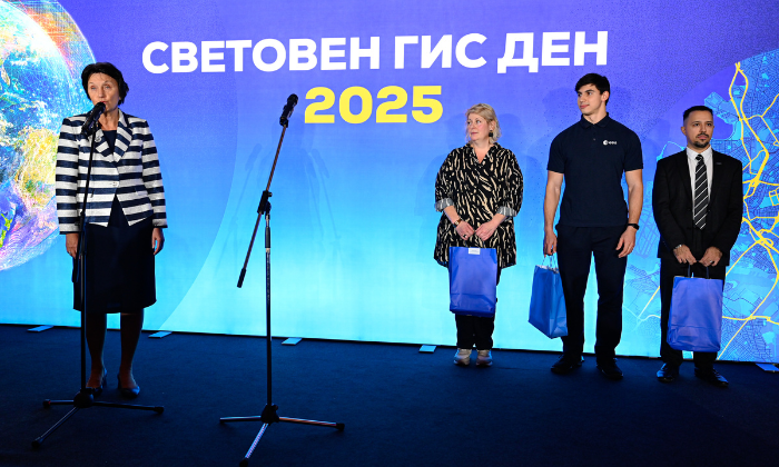
Photo: Lilia Yotova
On November 19, at Grand Hotel Millennium Sofia, during the official ceremony marking World Geographic Information Systems (GIS) Day, the winners of the National Educational Competition “Studying the World with GIS” 2025 were announced and awarded. The competition is organized by Esri Bulgaria under the patronage of the Ministry of Education and Science and with the support of more than 40 partner organizations from various sectors.
This year, a special highlight of the ceremony was the participation of Deputy Minister of Education and Science Emilia Lazarova, who presented the awards in the “Teachers” category. “The Ministry of Education and Science supports the GIS community in Bulgaria and appreciates its efforts for the development of young people and the implementation of innovations through such projects,” said Ms. Lazarova.
In the third consecutive edition of the competition, nearly 180 teachers, students, university students, and doctoral candidates from across the country took part. They created a wide range of GIS projects using the most powerful web GIS platform, ArcGIS Online – interactive maps, dashboards, digital stories, educational resources, innovative lessons, spatial analyses, and more.
The competition entries were evaluated by an expert jury composed of: Prof. Dr. Stoyan Nedkov (National Institute of Geophysics, Geodesy and Geography, Bulgarian Academy of Sciences); Chief Assistant Prof. Dr. Leonid Todorov (Department of “Geospatial Systems and Technologies”, Faculty of Geology and Geography, Sofia University “St. Kliment Ohridski”); Chief Assistant Prof. Dr. Mila Yolova (urban planner, Department of “Urban Planning”, Faculty of Architecture, University of Architecture, Civil Engineering and Geodesy); and Dr. Eng. Denitsa Savova-Georgieva, Head of Education at Esri Bulgaria.
During World GIS Day, the virtual exhibition featuring all competition projects was also presented. The gallery can be viewed here.
The awards from the National Educational Competition “Studying the World with GIS” 2025 were granted to:
Category “Teachers”:
1st place: Asya Nazif – 203 Foreign Language High School “St. Methodius”, Sofia;
2nd place: Dimitrina Dokimova and Anton Atanasov – Mathematical High School “Dr. Petar Beron”, Varna;
3rd place: Yordan Adolfov – Vocational High School of Tourism “Ivan P. Pavlov”, Ruse.
Category “Students”:
1st place: Iliya Kirov – Mathematical High School “Dr. Petar Beron”, Varna;
2nd place: Stefani Radeva – Secondary School “Hristo Botev”, Ruse;
3rd place: Mihail Lazarov – National High School of Mathematics and Natural Sciences “Acad. Lyubomir Chakalov”, Sofia.
Category “School Team”:
1st place: Slavi Gavrilov, Velko Kozhuharov and Elka Ilieva – Sofia High School of Architecture, Construction and Geodesy “Hristo Botev”, Sofia;
2nd place: Dobromir Ivanov, Yoana Macheva, Kamelia Stoimenova, Maria-Magdalena Mincheva and Tamara Takova – Secondary School “Hristo Botev”, Ruse;
3rd place: Lilyana Stamenova, Stefan Stamenov and Vanya Stamenova – Space School.
Category “University Students”:
1st place: Eftim Futekov and Tanislav Ivanov – Sofia University “St. Kliment Ohridski” and Technical University of Sofia;
2nd place: Viktoria Yakimova – University of Architecture, Civil Engineering and Geodesy, Sofia;
3rd place: Viktoria Spasova and Daniel Dyulgerski – University of Architecture, Civil Engineering and Geodesy, Sofia.
The project that won the Audience Award is “Journey through the Celestial Heritage of Bulgaria” by Iliya Kirov, an 11th-grade student from the Mathematical High School “Dr. Petar Beron”, Varna.
The “GIS in Schools” program, within which the competition is held, is implemented by Esri Bulgaria in partnership with the Ministry of Education and Science and Sofia University “St. Kliment Ohridski”. The initiative already covers more than 400 schools in the country, which have access to free GIS software and educational resources. Nearly 1,400 teachers and almost 16,300 students use ArcGIS in their learning activities, projects, and extracurricular initiatives, developing practical skills in working with geographic data, spatial thinking, and digital literacy. For more details, visit the “GIS in Schools” website.
###