Esri Bulgaria together with leading organizations presented the best GIS projects and nationally significant systems in many spheres.
On November 16, for the 23rd time, Esri Bulgaria and over 40 partners organized the largest GIS forum in our country, dedicated to the World Day of Geographic Information Systems. The motto of the event was “With GIS we build a sustainable future together”. The online conference provided an opportunity to exchange experience between our and foreign experts in areas such as environment, engineering infrastructure, disaster planning, urban planning, transport and many others. The capabilities of the latest GIS systems and projects implemented in Bulgaria for various organizations, including Ministry of Environment and Water, the Ministry of the Interior, Overgaz, Executive Agency “Maritime Administration”, Silistra Water Supply and Sewerage and many others, were demonstrated to the hundreds of participants.
Traditionally, the forum was opened by Evgenia Karadjova, founder and manager of Esri Bulgaria, who stated: “Our environment is a complex, highly interconnected system. We can understand the interrelationships between objects and processes by building a common geoinformation model of Bulgaria. Stepping on this unified geo-informational basis, investing knowledge, experience, research, new data, incorporating vision and strategies – we will be able to move forward, build the next steps for our future development.”

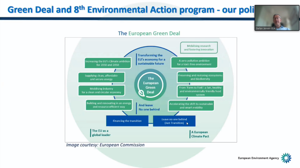
Among the special guests at the event was Stefan Jensen, Director of Data, European Environment Agency, who spoke about the role of spatial data in European green transformation policies. He told the visitors that “digitalization is a key factor in unlocking the potential of data. Systemic and cross-sector business cases need more types of data, and we need to continue to promote interoperability, with data ecosystems being exactly the way and place to organize this.”
Another special guest from abroad was Rahim Dobariya, Programme Manager Geospatial Information, AKAH, who presented how they are applying science-based and GIS technologies for the organization in conducting short- and long-term disaster risk management activities in international scope.
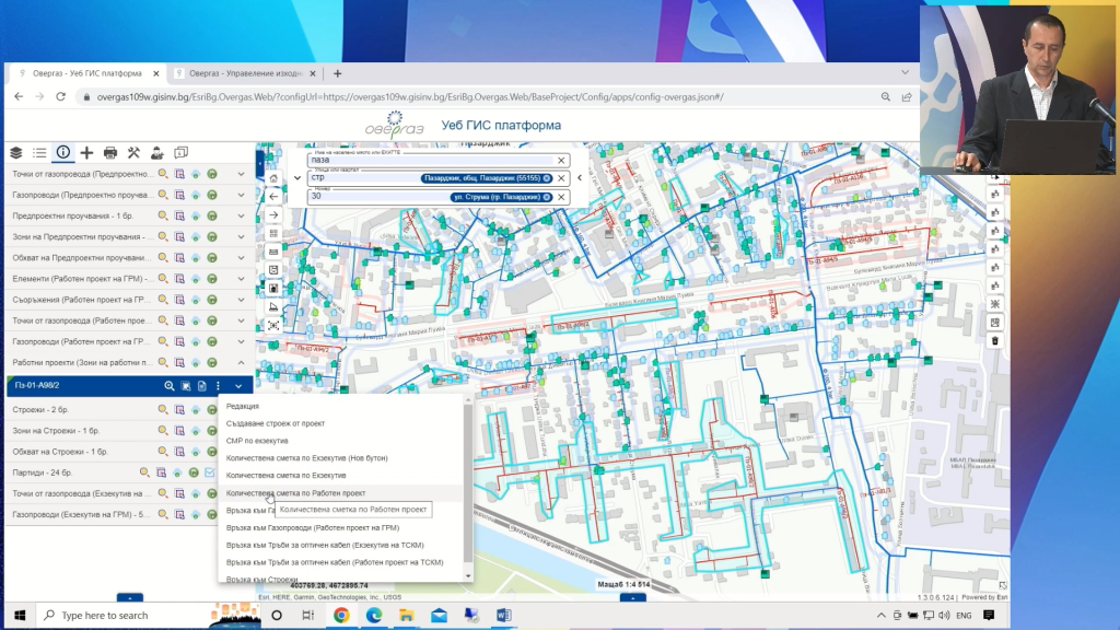
During the conference, current GIS projects implemented in various spheres in Bulgaria were also demonstrated. Sasho Donchev, executive director of Overgas, spoke about the advantages of the GIS-based system implemented in the company, which allows better care for each and every customer. The GIS system of Overgas has undergone an extremely large development, it became clear at the conference, and allows support for all steps of research, planning and construction of the gas transmission network.
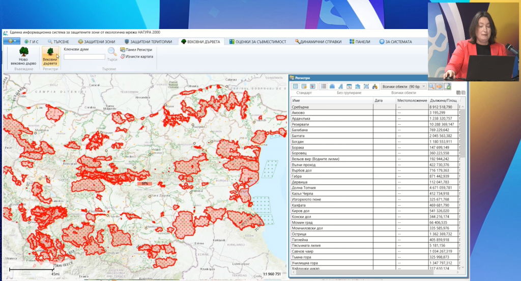
Among the other interesting demonstrations were the presentation of the upgraded Unified Information System for the Natura 2000 project, which now meets the modern needs of users, as well as the MoEW Flood Risk Management Information System, which focuses and manages data and processes, related to the risk of floods throughout Bulgaria. The capabilities of the GIS system implemented in Silistra Water Supply and Sewerage were also presented, as well as how the Executive Agency Maritime Administration uses GIS to increase transport safety in the common Bulgarian-Romanian section of the Danube River by improving the response to disaster situations.
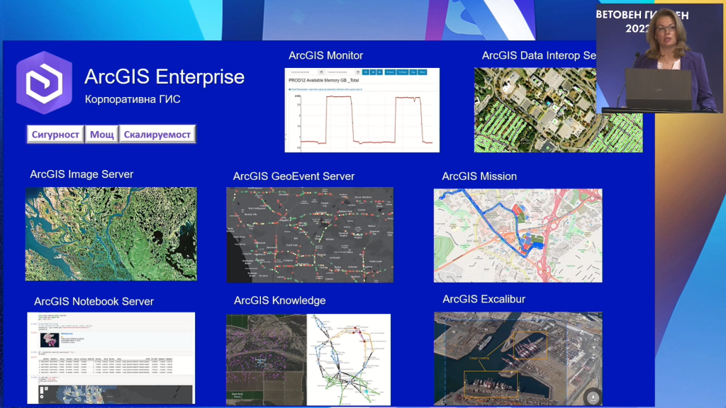
With many live demonstrations, the Esri Bulgaria team introduced the participants to the technological innovations in the ArcGIS platform, including the possibilities for geoanalysis, integration of machine learning and Geospatial Artificial Intelligence (GeoAI), real-time GIS, reality management (Reality Capture) and many others, which can be applied to the needs of different spheres.
Assoc. Dr. Steliyan Dimitrov from the National Geoinformation Center at Sofia University presented their work on climate change assessment and UAV imaging and flood damage assessment in Karlovsko this fall.
Mariyana Hamanova from Cleantech introduced the conference participants to the newly established Digital Innovation Hub in Construction, which through wider application of GIS and BIM will contribute to accelerating the digitization of the construction sector in our country.
Prof. Desislava Petrova from GATE talks about the work of the Institute for 3D Urban Modeling.
As part of the World GIS Day, STEM projects created by children from the 6th and 7th grades of “Alexander Georgiev-Kodjakafaliyata” Elementary School, Burgas city, were also shown as a part of the Esri Bulgaria “GIS in School” program.
About the event and partners
World GIS Day 2022 in Bulgaria is organized by ESRI Bulgaria in partnership with 40 leading organizations from various fields in our country, among them: Sofia University “St. Cl. Ohridski”, Faculty of Economics at Sofia University, Bulgarian Association of Software Companies, National Association of Municipalities in the Republic of Bulgaria, Foundation for Local Self-Government Reform, Union of Surveyors and Land Planners in Bulgaria, Union of Architects in Bulgaria, Union of Urban Planners in Bulgaria, Chamber of Builders in Bulgaria, Bulgarian Water Association, AFSEA Section Sofia, Association of Police Chiefs, Bulgarian Chamber of Commerce and Industry, Bulgarian Chamber of Commerce, American Chamber of Commerce in Bulgaria, Digital National Coalition, Move.bg, Bulgarian Cartographic Association, Bulgarian Academy of Sciences, University of Architecture, Construction and Geodesy, University of Mining and Geology, University of Forestry, Southwest University “Neofit Rilski”, New Bulgarian University, Technical University, Society for Preservation of Nature and Cultural Heritage with GIS – Bulgaria Branch, Educational Initiative ” Space School”, Green Balkans, Bulgarian Geographical Society, National University Center “Geospatial Research and Technologies” at Sofia University, Bulgarian Red Cross, Center for Research, Building and Improving NATO Capabilities for Crisis Management and Disaster Response, Bulgarian Chamber of Mines and Geology, Bulgarian Natural Association gas, Road Safety Institute, Electronic Communications Association, Technology Industry Alliance, Bulgarian Association for Geospatial Information Systems. Media partners: BNR, bTV Media Group, Gradat Media Group, Digitalk, DIR BG, National Geographic Bulgaria.
###