The largest GIS event in Bulgaria gathered online more than 800 participants from various fields.
GIS – a necessary platform for sustainability and cooperation was the focus of the online conference with which Bulgaria marked the World Geographic Information Systems (GIS) Day this year. The event provided an opportunity for hundreds of participants to meet with leading international and Bulgarian experts in various fields, including environment, urban planning, engineering infrastructure, and many others.
“The enormous challenges and fundamental changes in our world require much wider use of the GIS technologies. It is time to move more boldly from the stages of registration and visualization to analysis and modeling, forecasting, planning, prevention, and action. GIS and the geospatial approach provide the framework for the widespread application of integrated geo-knowledge throughout the process.” With these introductory words, the General Manager of ESRI Bulgaria Evgenia Karadjova opened the forum.
The main focus of the program was the use of GIS to support the implementation of the Green Deal. The special guest at this session, Chris Steenmans, Head of Data and Information Services at the European Environment Agency, who presented Europe’s progress towards a green transition and how GIS can help move towards a sustainable Europe. Working with high-quality geospatial data and knowledge is at the heart of achieving the EU’s ambitions in the field of environment and climate. At this stage, the agency offers more than 14,000 datasets that are used to perform comprehensive integrated assessments by priority areas.
The application of the GIS-based hub for better cooperation and coordination in measures to achieve the UN Sustainable Development Goals was presented by Stephen Keppel, co-founder of the UN Sustainable Development Data Alliance and President of the PVBLIC Foundation.
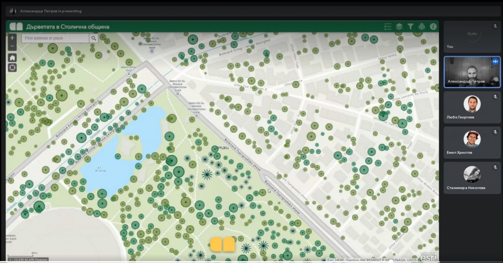
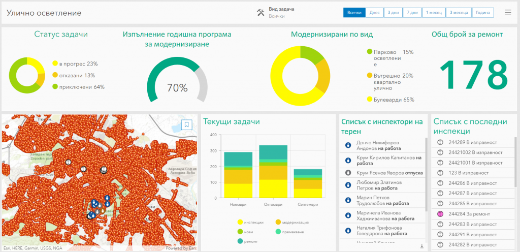
During the conference, current GIS projects implemented in various fields in Bulgaria were demonstrated. The Sofiaplan team presented the projects for Tree Mapping, the Green Ring, the Urban Development Units, as well as the Geoportal of Sofia Municipality, which already offers open access to its data through ArcGIS Rest services. Through the Geoportal everyone can use the information about green systems, streets, kindergartens, population, technical infrastructure, and other data about their projects. In the utility sector, Overgas demonstrated its strategic GIS platform for the control and management of corporate processes. The Ministry of Environment and Water presented the project for Flood Risk Management Information System.
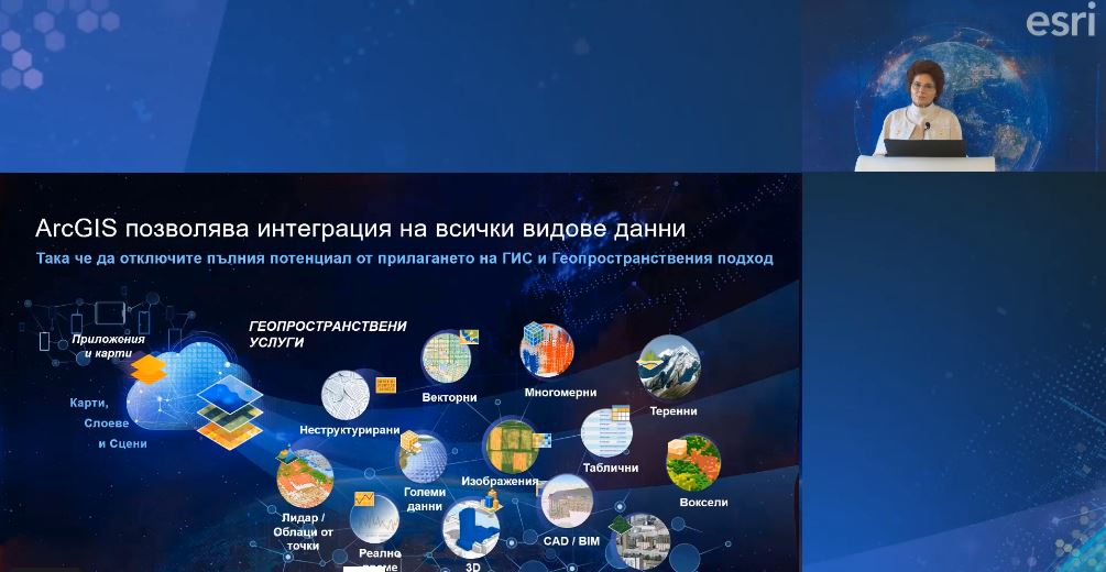
With many live demonstrations, ESRI Bulgaria team introduced the participants to the technological innovations in the ArcGIS platform, including opportunities for geoanalysis, integration of Machine Learning and Geospatial Artificial Intelligence (GeoAI), real-time GIS, Reality Capture, and many others. which can be applied for the needs of different areas.
As part of the World GIS Day, the winners of the first National Educational Contest “Digital Stories from School and University” were announced. The contest was held in partnership with the Ministry of Education and Science.
In the category “Teachers” the awarded maps are:
- 1st place: “The Road to Immortality” by Nora Balanska, teacher from Sofia University “Sava Dobroplodni” Shumenсмъртието” https://bit.ly/3Fp1pZg
- 2nd place: “The majestic Pirin – geographical location and nature” by Katerina Popova, teacher from Nikola Parapunov Primary School, Razlog https://bit.ly/3cjUGmB
- 3rd place: “The covered karst around Belogradchik” by Stefan Petrov teacher St. St. Cyril and Methodius, Vidin https://bit.ly/3Dmh22Z
- An additional prize was won by the storymap “Com-Emine. How to learn geography in a fun way of Kamen Travlev ”by Kamen Travlev, a teacher at the Vocational High School of Agriculture, Forestry and Tourism“ NY Vaptsarov ”, Chepelare https://bit.ly/3x14BqE
In the category “Students” awards are won by::
- 1st place: “MG geo trips. (non) competitive walks near and far ”by Daniel Dimitrov, 11th grade student at the Varna Mathematical High School “Dr. Petar Beron” https://bit.ly/3kF9KzK
- 2nd place: “Rila is dear to us” by Delyan Penkov, student in 6th grade of Innovative High School “Father Paisii”, Samokov https://bit.ly/3FrsmeR
- 3rd place: “Rays to the 100 national tourist sites” by Ivaylo Kartev, a student of 9th grade at the Mathematical High School “Academician Kiril Popov”, Plovdiv https://bit.ly/3HkFiom
In the category “Students and PhD students” are awarded:
- 1st place: “The characters in the shadows. The story of ordinary people with extraordinary hearts “of Angela Petrova, Student at Sofia University “St. Kliment Ohridski” https://bit.ly/3oR9fUT
- 2nd place: “From the desert to the metropolis – Abu Dhabi” by Nadia Petkova, a student at Sofia University “St. Kliment Ohridski” https://bit.ly/3wP4E8Y
- 3rd place: map “The great life and mountain peaks of Boyan Petrov” by Victor Goleminov, a student at Sofia University “St. Kliment Ohridski” https://bit.ly/3co3uI5
A gallery with all over 100 stack cards submitted in the competition is available here: https://bit.ly/3CpSMLY
World GIS Day 2021 in Bulgaria is organized by ESRI Bulgaria in partnership with 40 leading organizations from various fields in our country, including: Sofia University “St. Kl. Ohridski ”, Bulgarian Association of Software Companies, National Association of Municipalities in the Republic of Bulgaria, Foundation for Local Government Reform, Union of Surveyors and Land Surveyors in Bulgaria, Union of Architects in Bulgaria, Union of Urbanists in Bulgaria, Chamber of Builders in Bulgaria, Bulgarian Water Association, AFSEA Section Sofia, Association of Police Chiefs, Bulgarian Chamber of Commerce and Industry, Bulgarian Chamber of Commerce, Digital National Coalition, Move.bg, Bulgarian Cartographic Association, Bulgarian Academy of Sciences, University of Geography and Architecture, Civil Engineering University of Geology, University of Forestry, Southwestern University “Neofit Rilski”, New Bulgarian University, Society for Preservation of Nature and Cultural Heritage with GIS – Bulgaria Branch, Green Balkans, Bulgarian Geographical Society, Geographer BG, Bulgarian Red Cross, Research Center building and improving NATO’s governance capabilities of Crisis and Disaster Response, Bulgarian Chamber of Mining and Geology, Bulgarian Association of Natural Gas, Institute for Road Safety, Association for Electronic Communications, Bulgarian Association of Cable and Communication Operators, Bulgarian Association for Geospatial Information Systems. Media partners: BNR, bTV Media Group, Gradat Media Group, Digitalk, DIR BG, National Geographic Bulgaria.